 Using Canton, KY and our little condo as a home base, we ventured south to find Shiloh, Tennessee. Shiloh was a rail hub for the South during the Civil War and the Northern armies wanted to control the rails so the South would be split in two and would have no direct lines for supplies to their troops. Thus, the battle of Shiloh. As with most of the history of this terrible war, it was a bitter battle with high costs on both sides. But, Gen. Grant prevailed and managed another major victory in the South.
 The landscape on the way to Tennessee was similar to what we had seen in Kentucky. Only we were able to spot some distinctive crops along the way: tobacco drying on racks in the fields or in barns, and fields and fields of cotton popping from their pods in the early October sunshine. Again, our route was mostly back roads, as there seems to be no direct north or south; east or west road in Tennessee.
  Looking at the map it is easier to understand why. All of southern Kentucky and all of Tennessee looks like a map of the veins in the body. Each little vein on the map represents a river or a creek. So, understandably, there are no straight roads for a direct route to anywhere since the early roads followed the rivers.
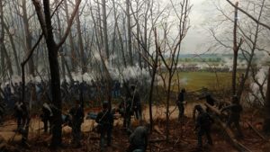
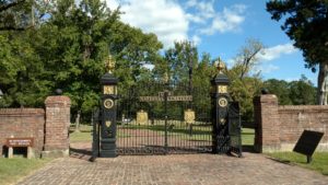 After many twists and turns through small towns, along farmland, and though thick growth, we arrived at Shiloh. It is the site of the battlefield park and National Cemetery some distance from any real civilization. First, we viewed the very excellent film at the Visitor Center to give us an overview of the struggle over the two days of the battle. We walked the immediate grounds by the cemetery and ate our picnic lunch in the Fall sunshine that was offering us an 82 degree afternoon.
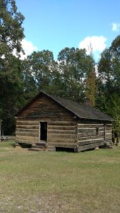 We followed the driving tour through the battlefield and read about the conflicts that took place at each stop along the way during those fateful days in April, 1862. Satisfied we had seen all the park had to offer, we stopped in the bookstore. Being the only ones in the bookstore, the attendant asked where in the North we were from . . . and, I had to ask him to repeat himself as I couldn’t understand a word he said. This wasn’t a movie we could stop and play back because we didn’t understand the dialect. Truly, I was surprised I couldn’t understand him, but his Tennessean accent was thicker than a bale of cotton. “Wur y’all frum in da North?” My driver answered, “Seattle.” To which he replied, “Seattle! That’s not north. That’s West.” Hum. Was there an answer to that conclusion? We decided not to engage him. So, undeterred, he continued to enlighten us with bits of lore and whimsy that surly have a long history in the area. I bought my pin and patch and we finally found our way to the car for our return trip to Canton.
 We back tracked the same roads we had used on the way to Shiloh; only traveling in the opposite direction provided a completely different view of the very same landscape. The late afternoon light is my favorite time for photography and I wished we could have stopped at every beautiful scene. But, we traveled on. As we crossed the Land Between the Lakes – and both lakes – to make our way back, the clouds had turned a soft pink and were mirrored in the silver blue of the lake water.
“Home” again, we warmed up leftover pizza from the other day and accompanied it with a side of chili mac and cheese. Our outing to Shiloh was complete and we are so glad we went. Shiloh marks the farthest point South we will go on this trip – and that was almost to the border of Mississippi.
Technical difficulties arise here at inopportune times. But, I think I’ve got the pictures documenting the day. Thanks for your patience.